Showing posts with label urban renewal. Show all posts

Friday, January 21, 2011

Last Days in Poletown

A couple weeks ago, I wrote about Poletown, a Polish community just east of downtown that was demolished in order to build the General Motors Detroit-Hamtramck Assembly Plant. I recently found that several sets of photographs were taken of Poletown as part of the Historic American Buildings Survey, a federal program intended to document America's architectural heritage. These two pictures show the Chene Street Commercial District, a section of Chene between I-94 and East Grand Boulevard which was completely erased from the grid for the sake of the plant's construction.


Corner of Chene and Milwaukee. (Image from the Library of Congress)


Chene between Trombley and Piquette. (Image from the Library of Congress)


These photographs were taken in 1981, right at the height of the controversy over the city's decision to displace the neighborhood's residents. The neighborhood appears to be on its last legs. Cars can still be seen in the street and parked along the curbs, but the buildings look dilapidated and the pictures give off a generally desolate feeling. Residents had begun taking relocation payments from the city and moving out of the neighborhood by this time, but the photographs may suggest that Poletown had emerged from the last couple decades in fairly rough shape, anyways. Documentation included in the Historic American Buildings Survey report hints at this, claiming that "the 1950s generally were very hard on the area" due to the steady movement of jobs and residents to the suburbs. The report goes on to say that "to the people of the area, the event which triggered the economic and social decline of the [Chene] Street Commercial District was the construction of the Ford Expressway (Interstate 94)." The report, from the Historic American Buildings Survey, can be found here.

Apparently, the construction of I-94 had cut Poletown into a north and a south section, which had done irreversible damage to the neighborhood by displacing some residents and breaking links between the remaining ones. This very closely resembles the way Corktown was split into two sections by the construction of I-75. It seems that by the time the neighborhood was scheduled for demolition in the 1980s, it was already on the decline.

On March 30, 1981, Time Magazine ran an article called "The Last Days of Poletown," which stated that 90% of Poletown residents had accepted relocation. The author writes that while a small group of protestors fight against the city, "other residents contend that the plant is actually a godsend, for it gives them the chance to leave the aging community and still get a decent price for their homes. Says John Kelmendi, 27, an area resident: 'Ninety percent of the socalled silent majority here want to go'" (Time Magazine, March 30, 1981).

So, these pictures may depict a neighborhood that has reluctantly accepted its fate after years of decline.

Thursday, January 20, 2011

The Consequences of Progress: Corktown

I'm really interested in how urban planning decisions that are intended to improve neighborhoods can have terrible long-term consequences. Urban renewal was a concept based on the idea that city governments could take an active role in redeveloping land and revitalizing cities. It became popular in America in the middle of the twentieth century. Corktown, an originally Irish neighborhood located immediately southwest of downtown, was threatened by several development projects over the course of its life, but it has emerged in relatively good shape.

A few of these projects involved transportation. Ironically, the automobile both built Detroit and contributed to its demise as the freeway system cut the city into sections, many of which withered away as neighbors were separated from each other and from commercial districts. In the 1950s, the construction of the John C. Lodge freeway, which ran north from Jefferson, separated Corktown from downtown. Some of the eastern edge of the neighborhood was demolished for the construction.


In this c. 1950s photograph, the Lodge freeway (seen from left to right near the middle of the frame) can be seen running under Michigan Avenue towards the Detroit River. Beyond the concrete river is Corktown and the rest of Southwest Detroit. (Image from the Wayne State University Virtual Motor City Collection)


In the 1960s, the Fisher Freeway was built right through the middle of Corktown, just north of Michigan Avenue. The freeway intersected with the Lodge at the edge of the neighborhood and basically split it into two sections, north and south. North Corktown, as it is now called, did not fare as well as its southern neighbor, probably because it was cut off from Michigan Avenue, the main commercial anchor of the neighborhood. North Corktown is now an almost rural landscape, with many abandoned lots and some scattered homes. Driving north on Rosa Parks Blvd over the Fisher Freeway, the contrast between the southern portion of the neighborhood and the bizarre peacefulness of North Corktown is striking. The comparison to the rural country may be somewhat accurate, as some farms have emerged in between the grassy lots. A few Corktown establishments, like Nancy Whiskey, have been able to hold on over the years in the area north of the freeway.


Harrison Street in North Corktown. (Image from Google Maps)


The two freeway projects were not the first transportation-related plans to affect Corktown. In the early twentieth century, Michigan Avenue was widened to make room for increased automobile traffic. This required the demolition of the southern portion of the street to accommodate the extra lanes. Today, with the population of the neighborhood and city far below what they were at the time, Michigan Avenue seems desolate and incredibly spacious. I should note that the surplus of lanes would make plenty of room for a light rail line extending from the southern end of the Woodward line and traveling through Corktown and Mexicantown, but I won't count on it. Still, this could make positive use of a situation that originally caused the destruction of much of the neighborhood's major street.

Probably the most significant threat to Corktown came in the form of an urban renewal project. The city sought to demolish much of the neighborhood in order to re-zone the land for industry. Fortunately, resistance from the neighborhood was strong enough to prevent much of the potential damage from being done. The core strength of the neighborhood may also be one of the primary reasons that Corktown has been experiencing a small renaissance in the past few years. Armando Delicato and Julie Demery write that "today many of the buildings that were to save Corktown are abandoned while the remnant of the old neighborhood is resurging" (Detroit's Corktown, 40). Hopefully, the neighborhood can see a steady, organic renewal that forms it into something new and exciting but still connected to its beginnings.

Sunday, January 9, 2011

Evidence of Poletown

Last winter, I spent some time at the Detroit Historical Society helping to catalog photographs taken by former students at the College for Creative Studies. One day, I was going through some miscellaneous photographs of residential neighborhoods, and I began looking up the addresses of some of the homes. One photographer had taken a series of shots of some small single family homes on St. Aubin, and I didn't recognize the cross streets he listed under the photographs, so I was doing some Google Maps investigation. I couldn't seem to locate the intersections where these photos were supposedly taken. Google Maps told me they didn't exist, and I searched up and down St. Aubin a few times. I was starting to wonder if the photographer had made a mistake and completely mislabeled the photos. After searching the map several times, I realized that the huge space directly adjacent to the area in which I thought these homes would be located was the General Motors Hamtramck Cadillac Assembly Plant.

I didn't know too much about the Assembly Plant, besides that it was constructed on the site of a large immigrant community called Poletown. Poletown was one of the few communities still thriving in Detroit by the 1980s, but the city of Detroit seized it through eminent domain, claiming that the potential for job creation brought in by a new GM plant would outweigh the benefits of keeping the community intact.

The pictures I was looking at were taken in 1981, and they showed rows of homes which were in various states of disrepair but still appeared to be in decent shape. Many of them were located on a stretch of St. Aubin which was right on the edge of the Assembly Plant and, as far as I can tell, no longer exists. I had heard some vague rendition of the story of Poletown, but seeing pictures of entire city blocks which stood in 1981 but have completely disappeared made the whole thing seem more like reality and not just a piece of Detroit political history.

Of course, it's tough to know what conditions were like in Poletown in the 1980s without actually having lived there. Even by interviewing former residents of the neighborhood, I'm sure we would get conflicting opinions about the neighborhood's reaction to the deal. For example, David Schultz writes in Property, Power, and American Democracy that the Poletown Neighborhood Council (the organization created to oppose the demolition) was actually fairly unpopular among Detroit's Polish community, which saw the potential economic benefits of the plant's construction for nearby Hamtramck and was offered significant payments for relocating (pg. 101). On the other hand, it's important to remember that this was a community, and there was at least some segment of it that vigorously opposed the deal. Jeanie Wylie's book, Poletown: Community Betrayed, represents the viewpoint that it is an injustice any time a community is sacrificed for the benefit of some external power, and it is widely acknowledged that this expansion of eminent domain gave governments and corporations an unprecedented amount of control over private property. These complicated issues are always important to remember, especially as the city attempts to deal with its current land use issues by attempting to incentivize residents to move out of what it considers to be unsustainable neighborhoods through the Detroit Works project.

***

One of these photographs had a caption which read, "On St. Aubin between Henrie and Palmer," and it showed a row of six or seven houses. I located this block on Google Street View, and found that only one of the houses in this row remains, surrounded by trees but still appearing to be in good condition. The house is only a few blocks from the GM Plant and from I-94, which had done its own damage by splitting the community in half like so many Detroit freeways had done in other neighborhoods. Even though this block sits just outside the area demolished for the plant's construction, surely most of its inhabitants simply gave up and moved on to other places. I wonder if this house is occupied by some Polish family that was too stubborn to leave the neighborhood, like the few residents of Centralia, PA who refused to leave after a mine fire made the town uninhabitable. Maybe they choose to continue living in the house, painting the walls, and trimming the bushes as a symbol of this former immigrant community.

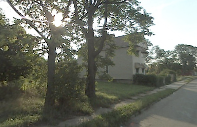


(photos from Google Maps)


***

Still, Poletown refuses to die. A few months ago, an article on detroitblog drew attention to St. Albertus Catholic Church, which is no longer an officially recognized church but is hanging on by a thread as a small group of people work to preserve it. A priest from Hamtramck occasionally bikes into the neighborhood to give masses to a handful of people. And the Ivanhoe Cafe, or "Polish Yacht Club" (not an actual yacht club, for the record), still serves fish and Polish food on a desolate section of Joseph Campau Street which was cut off from Hamtramck by the construction of the Assembly Plant. These people and others like them are evidence of the community's symbolic connection to this one random piece of land, and stories like this are repeated throughout Detroit's many forgotten neighborhoods.